This is a site to summarize the status of the Weiss family. A chronological account of the family - since 1986 is available as well as an account of a few remembered accounts. The former is at: http://weisschronicles.blogspot.com/ The latter is at: http://before1986.blogspot.com/

Friday, November 21, 2008

Ann, Beth and Martin in Zichron Yaacov


At Zichron Yaacov

It means the 'memory of Isaac' and the particular Isaac is not the patriarch but a member of the Rothschild family which founded, or reestablished the town.

The first image is a bus going down the main commercial outdoor mall, which is very nice but has lots and lots of cats.

The next image is a winery in the city. We didn't tour the winery because reservations were needed. Besides its basically a collection of large stainless steel containers.

The third image is Ann and Beth walking down the mall toward where I was (I was drinking a beer at the time which I had purchased from the local grocery which was also on the mall).

The next two pictures were taken from our room at the Havat HaBarone hotel. It means "Estate of the Baron" and the "baron' was one of the Rothschilds. One image is toward the north west. Some of Haifa is visible here (in the distance) as well as the outskirts of a hill that is part of Zichron Yaacov (on the right edge about half way up). The other image is toward the west and shows the narrow coastal plain - no more than about 3 miles wide at this point. The white covered
structures are greenhouses.


Thursday, November 20, 2008

odd Jerusalem stuff & a Tel Aviv image


Jerusalem Has Many Odd things to see.


The first image is a small park south of the center of the city. It is called "Lion Park". We passed it one day on a walk.


The second image shows the center of Tel Aviv as seen from the railroad station. We changed trains there on our way to the station close to Zichron Yaacov.


The third image shows that, like other countries, Jerusalem also has a street named for Martin Luther King.


Jerusalem 2nd Temple Model @Israel Museum


Jerusalem at the Time of the second (Third) Temple

Back in the early 60s someone created a 1 to 50 scale construction of what Jerusalem would have looked like in the days of Herod the Great.

This period is called the Second Temple period even though Herod knocked down the second temple (the one built in the days of Zarubabel) and built a new one on that site.

They did the best they could in their model. There are some errors that are fairly obvious. For example, the walls are not quite at the right places (neither the outer or inner walls) and the rooftops were not red back then. The outer wall in the time of Herod was further from the temple than the wall built by Sulimain in the 16th century.

Anyway, the first image shows what would have been the view from the top of the Mt of Olives.

The second image shows the steps on the south side of the temple. This is what the common folk would use to bring offerings.

The third image shows the view from the east (between the city and the Mt of Olives). There was almost no development on that side.

The fourth image shows the view of the tower of David toward the temple mount.

The fifth image shows the view from south of the city


Tuesday, November 18, 2008

The Dead Sea


At the Dead Sea, aka the Salt Sea

One of the things we did was go to the Dead Sea.

The first image is people swimming in the Dead Sea.

But before I could do this also I needed to buy a bathing suit and sandals so we went to this shopping center (second image) which advertises itself as the lowest elevation shopping mall on earth.


They don't claim to have the lowest prices on earth but the prices weren't bad and the hotels on the Dead Sea were very nice.


Beth Took both these images with digital camera purchased in Germany in May 08 when Ann and Beth were there.

Monday, November 17, 2008

Jerusalem - Old City


Old City Day - Nov 17

Ann and I went to the old city that day (also on other days this trip). This day, I walked around the archeological park, Ann went to a museum called the Burnt House which was the remains of the residence of a priest and his family that was burned by the Romans in mid Elul 70 CE.


I had the camera. The first image is that of the remains of Robinson's arch (on the wall) and the drawing of what Robinson's arch once looked like. There are a number of websites that explain Robinson's arch. One is hotlink. Basically, it was used to allow VIPs get to the Temple fast without encountering the general public.


The second image is a guy carrying a Torah Scroll. There was a Bar Mitzvah that morning. The Torah is a sefardic one and based on the uluing, I am pretty sure it was a Persian family doing the celebrating. In the backround are some stones that were at one time on the top of the wall but knocked down by the Romans in 70 CE.


The third image is Robinson's arch again this time showing the top of the wall.


The fourth image is a menorah modeled on the carvings made in the arch of Titus and also based on the desription of the menorah in the writings of Josephus.


The fifth image is a replica of one of the stones that was pushed off the wall by the Romans in mid AV in 70 CE. It has the enscription "The house of the trumpeters" in Hebrew. The trumpeters gather on the south west corner of the retaining wall of the temple and sounded notes before Sabbath and Holidays and also after the Sabbath and Holidays to let people know when to stop work and then when work could begin again. The original from which the replica was made is normal in the Israel museum and we saw it two days later in the Bible Lands Museum where it was on loan (while construction was ongoing at the Israel Museum).


The sixth image is Ann at a cafe in the upper city which overlooks the temple mount and the Mount of Olives (and actually has decent prices also).


I think it was called the Cafe of Gold. Ann spent some time there writing post cards.


The seventh image is from the south side of the Temple mount. It shows Columns that were erected during the 3rd Century by the Romans.

The stairs however were from the 1st century BCE. They were the stairs that would be used by the common folk to bring offerings. The stairs are built to have two short steps for every long step. This is thought to be done to prevent people from rushing forward.


Ann didn't have a camera to take images of the Burnt House.


Sorry about that.

Sunday, November 16, 2008

Ann, Martin and Beth (Tamar) at Neot Kedummim


Day at the Nature, Archeological Preserve

Sunday, November 16, 2008 we went to a place between Jerusalem and Tel Aviv (but closer to Tel Aviv) which has been 'reclaimed and enhanced' from the overgrazed hills.

The first image is of Beth at Solomon's pool. This is a place set up for weddings and so forth. The enhancements to this area consisted mostly of adding top soil near specialized plantings. However there was obviously some landscaping and hydrology work also.

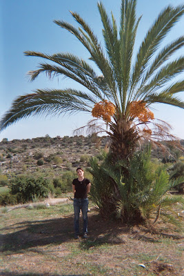
The next image is of Beth near a date palm tree. There are unimproved lands behind her. Beth's name in Israel is 'Tamar' which means date tree.

The next image is the "Golden Pond". I think the idea here was to have wedding processions that went from Soloman's pool to the Golden Pond or visa versa.

The Last image is Beth at a wine press. The 2nd century arch was reconstructed from material that was thought to be part of the original.


Labels:


Ann and Martin in Israel at Neot Kedumim

Another place we visited in Israel was a nature and archeology preserve called Neot Kedumim.

It is between Jerusalem and Tel Aviv but closer to Tel Aviv.

The image shows an olive press of 2nd century origin.

Beth took this with her digital camera.